This month marks the 80th anniversary of Ontario’s first superhighway: the Queen Elizabeth Way. Today, the QEW makes up a small part of the province’s continually expanding network of freeways. But on June 7, 1939, when it was officially dedicated by King George VI and Queen Elizabeth (for whom it was named), the highway was one of a kind.
The QEW started out as an unambitious highway project intended to relieve congestion on Highway 2 (Lakeshore Road) and Highway 5 (Dundas Street) between Toronto and Hamilton. As first conceived in 1931, the Middle Road (so named as it ran between the two existing highways) would be a new four-lane, undivided highway that would bypass towns such as Port Credit and Oakville.
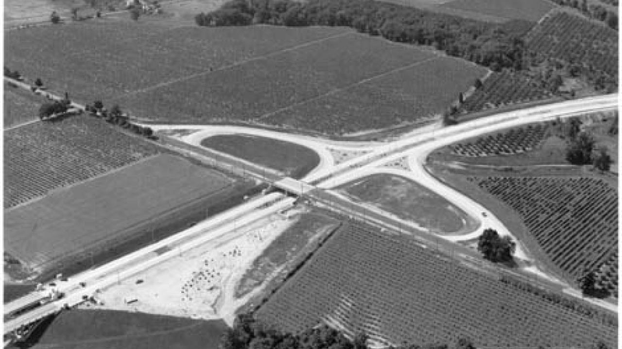
But when a new Liberal government, led by Mitch Hepburn, was elected in 1934, these simple plans transformed drastically. Inspired by the new autobahns being constructed in Germany, Minister of Highways Thomas McQuesten called for significant changes to improve safety and aesthetics. Under the new government’s direction, the highway right-of-way was widened to allow for a centre median, as well as grade-separated interchanges at major crossings. Canada’s first cloverleaf interchange was built at Highway 10 (Hurontario Street), and traffic circles were constructed elsewhere. The first section, a 39-kilometre stretch between Highway 27 in Etobicoke and Burlington, opened in 1937.
The new highway’s terminus was also shifted from Hamilton to Fort Erie in order to promote tourism and trade with the United States. A highway spur would connect to the new Rainbow Bridge at Niagara Falls, creating a link with the Niagara Parks system then also under development by the province. Several monuments were constructed: the highway’s entrance at the Humber River boasted a 12-metre-high column topped with a crown and with a lion at its base; the Henley Bridge, over Twelve Mile Creek at St. Catharines, featured ship’s prow emblazoned with the royal seal of Canada and the crests of all nine provinces. In addition, the new highway was fully illuminated.
By 1939, the stretch between Niagara Falls and Toronto was complete, though it wouldn’t be until 1956 that the QEW was fully paved to Fort Erie. At 109 kilometres, the QEW was North America’s longest divided highway (a record it would hold for just one year, as the Pennsylvania Turnpike opened in October 1940) and its longest continuously illuminated roadway.
But the QEW, as first built, would be unrecognizable to today’s motorist. Despite many innovative safety features, the QEW was not then a true freeway. The Middle Road had been upgraded from a dirt track, and in most places, it still offered direct access to adjacent properties. Despite new cloverleafs and traffic circles, most intersections were controlled by stop signs or traffic signals. And at Hamilton Harbour and the Welland Canal, traffic was snarled by lift bridges.
According to “The Queen Elizabeth Way: Ontario’s First Superhighway,” a government retrospective published in 1974, the QEW had become known as a “death trap” as early as 1954 — 15 years after the official opening. Traffic planners in the 1930s, it said, “had no way of estimating future highway traffic in Ontario, and the necessary width for divided highways.” At Oakville, a survey conducted in 1952 found that 500,000 motorists ignored traffic signals at the intersection of the QEW and Kerr Street, a crossing locally known as “Suicide Junction.” It was replaced by an interchange in 1957.
To improve safety, the Department of Highways of Ontario (predecessor to today’s Ministry of Transportation) pioneered frontage roads, also known as service roads, along the highway to eliminate driveway access to the increasingly busy route. In the 1950s, the province converted the QEW to a full freeway between Burlington and Toronto and built new skyways at Hamilton and St. Catharines. By the end of the 1970s, the QEW had been fully upgraded to freeway standards.
Lessons learned after the construction of the QEW have been applied to highways constructed since. New routes, including the Toronto-Barrie Highway, later renamed Highway 400 (Ontario’s unique numbering system for freeways predated the United States interstate highway system by five years), were built on entirely new alignments, eliminating the need for driveway access. Wider rights-of-way allowed for wider medians, larger interchanges, and future growth. Though Highway 401, completed between Windsor and Quebec in 1968, eclipsed the QEW in length and importance, it owes much to the experience gained from Ontario’s first superhighway.
In the years that followed, Ontario continued to cement the reputation for high safety standards that it first established with the QEW. When it came time to widen the 401 in the late ’60s, the DHO modified the cloverleaf design, which had originally featured eight loop ramps, to reduce weaving on high-speed roads: the partial cloverleaf, featuring just two off-ramps, improved safety, and only minor work was required to modify existing interchanges. While dozens of eight-ramp cloverleaf interchanges were built on the QEW, 400, and 401 from 1937 up until the 1960s, only one remains, at Belleville. The partial cloverleaf, or “parclo,” is now common throughout North America.
The Ontario tall wall represents another home-grown safety innovation In the early ’60s, North American highways used metal crash barriers or roughly 80-centimetre-tall concrete Jersey barriers to separate freeway traffic. At 107 centimetres, the new wall, which was tested by the DHO in the late ’60s, was more than 25 per cent taller. Several U.S. states — including New Jersey, which had developed the original — have adopted the Ontario standard because it not only creates a more effective barrier against larger vehicles, but also reduces the glare from oncoming headlights at night. The tall wall is now used on most sections of the QEW. (Ontario has also more generally been a leader in road safety: in 1976, it became the first jurisdiction on the continent to require seatbelt use, and in 1994, the first to institute a graduated-licensing system.)
Commuters in the Greater Toronto Area can thank the QEW’s legacy for one more transportation innovation. Although it had been widened and fully upgraded between Burlington and Toronto, by 1960, the QEW was once again reaching capacity. But there was no more room for expansion. So the province launched a commuter rail service — GO Transit — to help relieve congestion. GO Transit was the first commuter-rail service established in North America after the Second World War and became the model for other modern systems across North America.
If Ontarians enjoy some of North America’s safest highways — and statistics say we do — that’s in part due to the province’s record of innovation, which dates back 80 years to the opening of the QEW.